


Nestled in the Foot Hills of the North Georgia Blue Ridge Mountains

Aska Trails
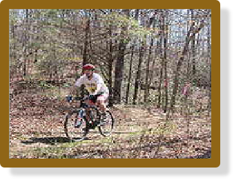
Open year-round, the Aska Trails Area offers hikers and mountain bikers 18 miles of trails from climbs to the tops of ridges to paths along the shores of Lake Blue Ridge.
The Aska Trails Area is a system developed on National Forest lands near Deep Gap on Aska Road in Blue Ridge. Trails range from one to 5.5 miles and are open to the public year round. Trails climb to 3,200 feet with views of mountain ridges and descend to the shores of Lake Blue Ridge. Two trails cross mountain streams, which provides a range of forested settings. This trail offers gentle to moderate hiking grades; however, the grades are challenging for mountain bikes. A hiker can expect to hike through forested areas with mature hardwoods and thickets of mountain laurel and rhododendron.
"The Gateway to the Blue Ridge Mountains"
Fannin County has an easily traversed corridor between two mountain wilderness areas; the Chattahoochee National Forest and the Cohutta Wilderness. The Cohutta Wilderness area is the largest wilderness area in the eastern US and is comprised of 36,000 acres lying in Georgia and Tennessee within the Cohutta Mountains, part of the Blue Ridge Mountain chain.
The Aska Trails System includes some of the following trails:
Stanley Gap Trail - 5.5 miles
Green Mountain Trail - 4.6 miles
Flat Creek Loop - 5.8
miles
Stanley Gap/Flat Creek Connector - .1 mile
Long Branch Loop - 2.0 miles
Directions: From Blue Ridge, go east 0.25 mile on Old U.S. 76 to Aska Road; turn right (south) and continue 4.5 miles to Deep Gap. The trail crosses the road just below gap. To reach Stanley Gap, go on Aska Road an additional 3 miles to Stanley Gap Road. Turn right on a gravel road and travel 4.2 miles to the trailhead. To reach the lakeshore, go 2.5 miles on the Aska Road and turn left on Campbell Camp Road; Travel 2 miles on Forest Service Road 711 to the trailhead.
Trailheads are located at Deep Gap, Stanley Gap, Shady Falls Road and Forest Road 711 by way of Campbell Camp Road. Parking fee is $2 per vehicle. Bulletin boards at trailheads show maps of the area and the trail system.
Directions from the Toccoa Ranger District Office in Blue Ridge (GA) to the trailheads:
Deep Gap- From McDonald’s restaurant at intersection of GA Hwy 515 and GA Hwy 5 in Blue Ridge. Go east on GA Hwy 515 (toward Blairsville) approximately 0.8 miles to Windy Ridge Road. At Windy Ridge Road turn right, go 0.2 miles to dead end with old U.S. 76. Turn left, go 0.2 miles to Aska Road on the right. Turn right, go south 4.4 miles to Deep Gap parking area below gap on the right side of road.
Stanley Gap- Go south on Aska Road 8 miles. Turn right on paved road (Toccoa Riverside restaurant on left). Parking area for trail is 4.1 miles on right.
Forest Road 711- Drive south on Aska Road for 2.5 miles to Campbell Camp Road. Turn left and follow main road 0.8 miles to Forest Road 711 intersecting from left. Follow 711 past private homes; turn right, trailhead 2.0 miles.
Shady Falls- Follow Aska Road south 5.9 miles to Shady Falls Road. Turn left, go 0.2 miles, parking area on left.
